I started to do a little bit of digging and discovered that there were at least two notable ice storms that hit Paducah and Metropolis. One of those was in 1902 and the other was in 1952. I believe that this recent storm was more severe than either of the previous. I am going to do a little more research in the coming weeks/months.
Cold weather has returned to our region. Temperatures are going to fall into the teens tonight.
February 19th, 2009
Posted by
admin |
Uncategorized |
no comments
Print This Post
|
Email This Post
After the last few weeks of excitement the area needed a bit of a break. So, the last few days have been rather calm. It appears a deep low will move across Missouri and Illinois later tonight, however. This will spark an area of showers and thunderstorms across most of our counties. It appears rainfall amounts won’t be overly impressive.
The heaviest totals should be in West Kentucky and Tennessee. Rainfall amounts could approach 1/2" in some areas.
The Storm Prediction Center has placed a slight risk for severe thunderstorms over portions of Tennessee. This looks reasonable - mainly a hail threat. Shear is strong. I would say that the KPAH region could see a few strong storms - especially over Kentucky.
We actually had a mixture of snow pellets and sleet this morning across portions of the region. I traveled through a bit of sleet and snow in Massac County around 10 AM. You could see a hint of it even on the ground.
A clipper system will approach the region on Friday night and Saturday. This will trigger another round of precipitation and usher in some colder air. The precipitation on Friday night and Saturday may come in the form of snow. There are still some questions on temperature profiles over our region. Something to keep an eye on!
February 17th, 2009
Posted by
admin |
Uncategorized |
no comments
Print This Post
|
Email This Post
We had several wind gusts over 60 mph yesterday. The KPAH (Paducah, KY) National Weather Service Office reported more than one 60+ mph wind gust. Amazing gradient with the tight low pressure area that pushed through the region yesterday. It started out around 999 mb in Missouri and ended up at 988 mb in Indiana. Significant wind damage was reported in the State of Kentucky.
We finally had a nice day of weather. Todays temperatures were mild and it actually felt like spring. Meteorological Spring is only a few weeks away!!!
Tonight’s sunset - my backyard.

February 12th, 2009
Posted by
admin |
Uncategorized |
no comments
Print This Post
|
Email This Post
Lots of rain falling this morning. The NWS has issued flood advisories for most of our counties - including Paducah. A high wind warning is also in effect. Thankfully we have managed to escape the tornado threat. An area of showers and thunderstorms is pouring on most of West Kentucky and South Illinois. Rainfall totals of 2-3" are being reported across portions of Ballard and Massac Counties.
High winds will likely develop across West Kentucky this morning and continue into the afternoon.
Major tornadoes hit Oklahoma overnight. Various media reports say anywhere from nine to fifteen people were killed and over one hundred injured. They called off searches at 1 AM. They will resume searches this morning. It sounds like an EF3+ tornado hit portions of southern Oklahoma.
10:45 AM - Pressure


Winds from Wright-Weather.com
February 11th, 2009
Posted by
admin |
Uncategorized |
no comments
Print This Post
|
Email This Post
Storm Prediction Center has placed our region in a slight risk for severe weather on Tuesday night and Wednesday morning. Here is the map for tomorrow (probabilities)

My current forecast:
February 9, 2009
***Updated for wind advisory and to increase confidence in severe weather threat Tuesday night - Wednesday***
UPCOMING THREATS:
Strong/gusty winds today (Monday) - high confidence (wind advisories have already been issued for portions of the State of Kentucky)
Strong to Severe thunderstorms Tuesday night into Wednesday - medium confidence
Strong/gusty winds on Wednesday - high confidence
***SPOTTER ACTIVATION IS POSSIBLE ON TUESDAY NIGHT AND WEDNESDAY - EMERGENCY MANAGEMENT OFFICIALS SHOULD KEEP ABREAST OF THE LATEST WEATHER INFORMATION***
PRIMARY THREAT AREA:
Entire Region
TIME PERIOD:
Monday-Monday Night - Winds over 30 mph (wind advisory in effect)
Tuesday Night - Wednesday - Severe thunderstorms (possible)
Wednesday - High Winds - Likely
Friday/Saturday - more precipitation is possible
Next Tuesday - another storm system is possible
A very active weather pattern continues to unfold across the Central United States with three storm systems moving towards our region between now and Saturday. Several rounds of precipitation can be expected during this time period.
System number 1 will cause winds to increase on Monday morning into Monday evening. Wind gusts over 30 mph will once again be possible across our entire region. This could cause some problems with broken limbs and trees across the ice storm damaged region.
There will be a chance for showers and thundershowers Monday night into Tuesday. Rainfall amounts should be less than 1/2".
Of greater concern is the development of a deep low pressure area (system number 2) on Tuesday night over Texas and Oklahoma. This storm will push northeast into Arkansas and Missouri on Tuesday night and Wednesday morning and will eventually move into Illinois and Indiana during Wednesday.
After looking at the latest data I believe there are two distinct threats from this storm system. The first risk of severe weather will accompany the warm front on Tuesday night and Wednesday morning. Any thunderstorms that form along the warm front could produce damaging winds, hail, and isolated tornadoes. This would be a late night and early morning threat. Emergency management should be aware of the "potential" of at least some severe weather entering West Kentucky during this time period. Confidence on how these storms develop and the exact placement of them remain low. There will be a greater risk across portions of Arkansas and Tennessee. Stay tuned for updates as the finer mesoscale features become clearer.
This storm also has the potential to bring heavy showers and thunderstorms (rainfall totals greater than 1" will be possible in the State of Kentucky) to our region during the day on Wednesday. Questions remain as to just how much instability will develop over our region on Wednesday. However, latest guidance indicates that there will be a squall line form across portions of Missouri and Arkansas that will sweep east/northeast at speeds exceeding 60 mph. This will cause a likelihood of damaging wind gusts down to the surface. This will be a thin and quick hitting line of storms. If winds can be realized then gusts over 60 mph would be possible ahead and behind the line of storms. Confidence is increasing in this event. Emergency management officials should keep abreast of fast changing weather conditions over the next 48-72 hours.
Time schedule for Wednesday’s storms:
West Kentucky (two possible rounds) - one in the late night hours of Tuesday/Early morning hours of Wednesday
West Kentucky late morning on Wednesday for round two.
Central/East Kentucky - late morning into the afternoon hours on Wednesday
The Storm Prediction Center has already placed our region in a severe weather risk for Tuesday night and Wednesday.
Storm Prediction Center: http://www.spc.noaa.gov/products/outlook/
In addition to high winds associated with any thunderstorm development we are also going to have to deal with gradient winds (winds due to the deep low pressure area) on Wednesday. Winds could gust over 40 mph from the gradient. This is only going to complicate repair of power lines.
Emergency management officials should keep abreast of the latest weather information through NOAA Weather Radio and local media. Spotter activation will be possible on Tuesday night and Wednesday. At this time the extent of instability has yet to be determined for Wednesday, however, there does appear to be at least some risk for severe thunderstorm development.
Dangling limbs, leaning power poles, and cracked trees/power poles could topple if we get a high wind event on Tuesday night and Wednesday. Those with an interest in this weather event should listen for later updates.
Looking down the road - another storm system (system 3) will likely impact the region on Friday/Saturday and yet another next Tuesday. But, that is a long way off and there is no reason to go into details, at this time. At this time the Friday/Saturday system appears to be mainly a rain event. There could be some change over to snow at the end of the storm. Again, a bit far to go into details on that storm. Model accuracy beyond day 3 is poor in a pattern like this. Needless to say - it will be active for some time to come.
Next update will be between 9-10 PM tonight
Beau Dodson
Meteorological Specialist for the Paducah/McCracken County Office of Emergency Management
February 9th, 2009
Posted by
admin |
Uncategorized |
15 comments
Print This Post
|
Email This Post
After our major ice storm last week it appears that we are about to enter a warm and moist period across the Ohio and Middle Mississippi Valleys.
A strong southwest flow is already developing ahead of what will become several storm systems over the next few days. The first system will push through on Monday night and produce some showers and isolated thunderstorms. A second and stronger system will then form over the Missouri Valley on Tuesday night and Wednesday. This system could bring a squall line across our region during the morning or afternoon hours on Wednesday.
At this time it appears that some damaging wind gusts and isolated tornadoes will be possible from the KPAH Region southward to the Gulf Coast. The exact track of this area of low pressure will be critical in any severe weather development.
A third storm system will approach the region next weekend. This will bring additional chances of showers and possible thunderstorms.
A return to winter may be in store after next weekend.
February 7th, 2009
Posted by
admin |
Uncategorized |
no comments
Print This Post
|
Email This Post
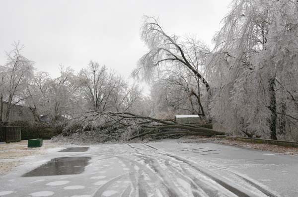
Most ice I have ever witnessed here in West Kentucky. Trees and tree limbs are falling all over the county. Large branches are hitting our house. We can hear crashes every minute now - branches breaking and falling over the neighborhood.
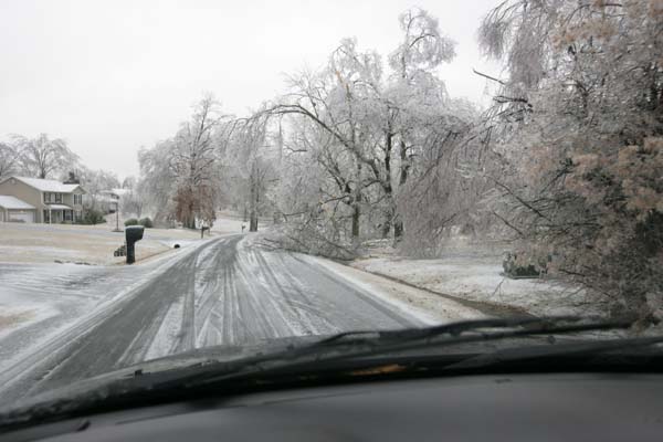
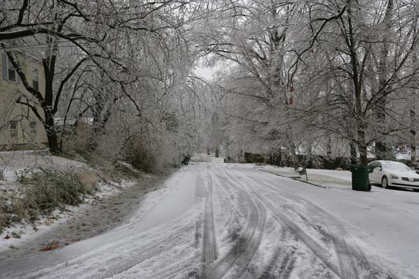
Paducah, KY


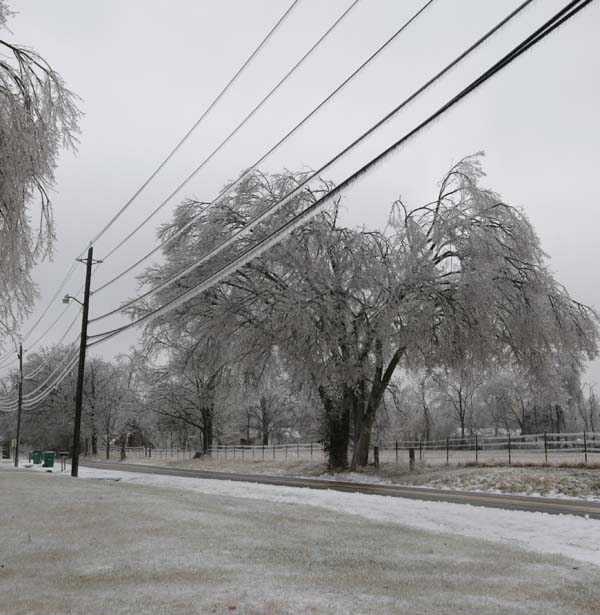
Paducah, Kentucky one of our properties
.jpg)
February 6th, 2009
Posted by
admin |
Uncategorized |
15 comments
Print This Post
|
Email This Post
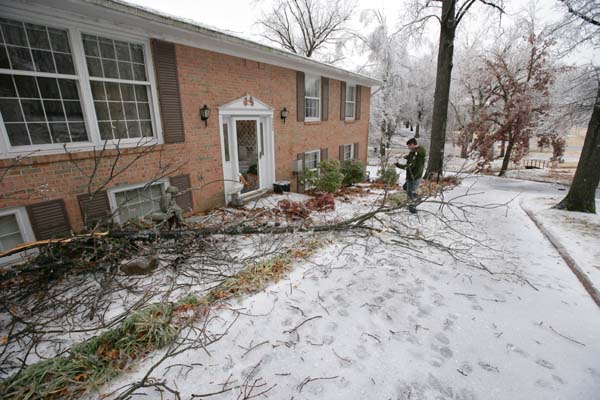
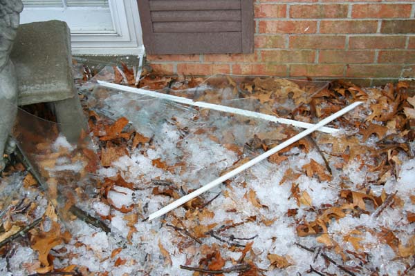
We lost one window. Tree branch. Power is going on and off. Comcast internet is gone. We have aircard only. Freezing rain continues. We can hearing popping noises everywhere. We can hear loud humming and transformer explosions. It is getting bad.
The precip should end on Wednesday afternoon - snow by then. Freezing rain and ice from now and through the night tonight (Tuesday night). This is going to get nasty unless we warm up a degree or two).
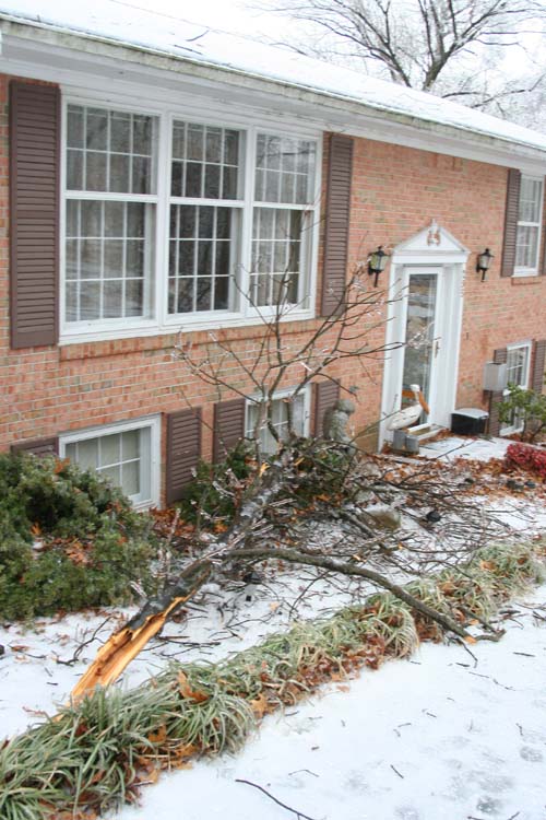
Front of the house - one window broken

February 6th, 2009
Posted by
admin |
Uncategorized |
no comments
Print This Post
|
Email This Post